Ashburn, Virginia
Ashburn, Virginia | |
|---|---|
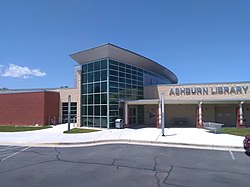
 Ashburn Library | |
| Coordinates: 39°02′37″N 77°29′15″W / 39.04361°N 77.48750°W[1] | |
| Country | United States |
| State | Virginia |
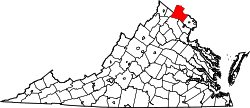
| County | Loudoun |
| Area | |
• Total | 15.55 sq mi (40.3 km2) |
| • Land | 15.30 sq mi (39.6 km2) |
| • Water | 0.25 sq mi (0.6 km2) |
| Elevation | 253 ft (77 m) |
| Population | |
• Total | 43,511 |
• Estimate (2019) | 49,848[3] |
| • Density | 3,259.1/sq mi (1,258.3/km2) |
| Time zone | UTC−5 (Eastern (EST)) |
| • Summer (DST) | UTC−4 (EDT) |
| ZIP codes | 20146, 20147, 20148, 20149[5] |
| Area codes | 703, 571 |
| FIPS code | [2] |
| ANSI code | 2584799[2] |
| GNIS feature ID | 1499063[1] CDP: 2584799[6] |
Ashburn is a unincorporated settlement and census-designated place (CDP) in Loudoun County, Virginia, United States. At the 2010 United States census, its population was 43,511,[4] up from 3,393 in 1990. It is 30 miles (48 km) northwest of Washington, D.C., and part of the Washington metropolitan area. Ashburn is a major hub for Internet traffic due to its many data centers.[7]
Etymology
[edit]
The name Ashburn is believed to have originated from “Ashburn Farm,” a 1,236-acre estate originally owned by John Janney, a prominent 19th-century Quaker lawyer and politician who served as president of Virginia’s Secession Convention in 1861. The property was later purchased by George Lee III in the 1870s, who is thought to have named it “Ashburn” either for the ash trees that dotted the landscape or possibly as a reference to the ash-colored soil or barn fires that had previously occurred in the area.[8] Originally a quiet farming village known as Farmwell , the area became apart of a larger plantation economy in Loudoun County. Ashburn remained largely rural through the early 20th century. It began to change significantly in the 1980s and 1990s with the expansion of the Dulles Technology Corridor and the construction of major planned communities such as Ashburn Village and Ashburn Farm.[9]
By the early 2000s, Ashburn had become a global internet hub earning nicknames like “Data Center Alley” due to its massive concentration of data infrastructure, which routes a significant portion of the world’s web traffic.[10] Today, Ashburn is a central part of Loudoun County’s high-tech economy and suburban expansion with preserved natural and historic landscapes such as the W&OD Trail and nearby farms and battlefields.[11]
Definition
[edit]
Ashburn is a census-designated place (CDP) in eastern Loudoun County, Virginia. While it does not have the political autonomy of an independent city, Ashburn serves as a major residential and economic center in the outer Washington, D.C. metro area. Identified primarily by ZIP codes 20147 and 20148, the Ashburn area includes several large planned communities such as Brambleton, Broadlands, Belmont, Loudoun Valley Estates, and Goose Creek Village. These communities all share Ashburn mailing addresses and are part of the region’s rapidly expanding population.[12] As part of the Washington-Arlington-Alexandria, DC-VA-MD-WV Metropolitan Statistical Area, Ashburn is known for its affluent neighborhoods, top rated public schools, recreational amenities, and a growing tech economy. It is also home to many professionals who commute to Tysons, Reston, and Washington D.C., while also offering a growing number of jobs in cloud computing, cybersecurity, and telecommunications.[13]
History
[edit]Ashburn, located in eastern Loudoun County, Virginia, was originally part of a rural agricultural region known as Farmwell. The land was divided among several estates during the 18th and 19th centuries, forming part of the broader plantation economy that defined much of northern Virginia. During the Civil War, Loudoun County was deeply divided, and while Ashburn did not see major battles, it was affected by nearby troop movements, raids, and the broader regional instability at the time.[14]

In the late 19th century, the arrival of the Washington and Old Dominion Railroad provided a transportation link that supported local farms and small industries, although Ashburn itself remained sparsely populated and primarily agricultural well into the 20th century. The W&OD rail corridor, now a regional trail, is one of the area's key preserved historical routes. Following the American Civil War, land ownership changed and farming practices shifted, but Ashburn continued to be defined by its rural character for many decades.[15]

Significant change began in the second half of the 20th century, particularly after the opening of Washington Dulles International Airport in 1962. This major infrastructure project spurred development throughout the surrounding region, and Ashburn's location made it a strategic site for future suburban and technological expansion. In the 1980s and 1990s, planned communities such as Ashburn Village and Ashburn Farm were constructed, transforming the area into a major residential zone within Northern Virginia’s growing suburban region. [16] By the early 2000s, Ashburn had become a hub for global internet infrastructure. A combination of reliable electricity and access to fiber-optic networks attracted major technology firms. The region developed the highest concentration of data centers in the world, earning the nickname “Data Center Alley.” Today, Ashburn is a central component of Loudoun County’s tech economy, supporting various technological industries in areas such ascloud computing and cybersecurity while also serving as a key residential area for workers in the greater Washington, D.C. metro region. [17]
Geography
[edit]Ashburn is located in eastern Loudoun County, 7 miles (11 km) southeast of Leesburg, the county seat, and the same distance north of Dulles International Airport. As drawn by the U.S. Census Bureau, the area counted as "Ashburn" extends north to Virginia State Route 7, east to Virginia State Route 28, and southwest to the Dulles Greenway (VA 267).[18] The Ashburn CDP is bordered to the north by the Belmont, Lansdowne, One Loudoun, and University Center CDPs; to the east by the Kincora, Dulles Town Center, and Sterling CDPs; to the southwest by the Moorefield and Broadlands CDPs; and to the west by the Goose Creek Village CDP.[18]
According to the 2010 United States census, the Ashburn CDP has a total area of 15.55 square miles (40.27 km2), of which 15.30 square miles (39.63 km2) are land and 0.25 square miles (0.65 km2) are water.[2] The area is drained by Broad Run, which flows northward through the eastern part of the CDP toward the Potomac River.
Subdivisions
[edit]The Ashburn CDP consists of many major and minor subdivisions such as Ashbrook, Ashburn Farm, Ashburn Village, the Courts and Ridges at Ashburn, and the Village of Waxpool.

Demographics
[edit]| Census | Pop. | Note | %± |
|---|---|---|---|
| 1990 | 3,393 | — | |
| 2010 | 43,511 | — | |
| 2020 | 46,349 | 6.5% | |
| U.S. Decennial Census[19] 2010[20] 2020 | |||
Ashburn was first listed as a census designated place in the 2010 U.S. Census.[20]
The United States Census Bureau defines Ashburn as a census-designated place (CDP). As of the 2010 census, the CDP had a population of 43,511 residents,[4] while the larger ZIP Code Tabulation Area (ZCTA) for Ashburn's 20147 ZIP code contained 54,086 people.[21]
Many of its residents commute into Washington, D.C. and the surrounding suburbs such as Tysons Corner and Reston to their places of employment.[22] The median household income as of 2009 was $100,719.[23] Median age in Ashburn is 31.6.[23] Ashburn's population is made up of 49% males and 51% females.[23]
The racial makeup of the CDP was 67.1% White (59.1% non-Hispanic White), 8.2% Black or African American, 0.2% Native American, 17.1% Asian, 0.0% Pacific Islander, and 5.4% from two or more races. Hispanic or Latino people of any race made up 11.8% of the population.[24] The total number of households accounted for in Ashburn was 22,555.[23] The median household size is 2.9 persons.[23] 98% percent of Ashburn residents have a high school degree.[23] Some 42 percent of Ashburn's population holds a four-year bachelor's degree;[23] 18 percent holds graduate degrees.[23]
Homeowners formed 80 percent of the population,[23] renters made up 13% of the population,[23] and 7% of housing units were listed as vacancies.[23] The median age of housing was 5.0 years.[23] The median housing value is at $630,000.[25]
Economy
[edit]Located within the Dulles Technology Corridor, Ashburn is home to many high-tech businesses. World Trade Center Dulles Airport is the second World Trade Center in the state.[26] Verizon Business has a major office in Ashburn at the location replacing MCI WorldCom's headquarters after its acquisition.[27][28] Ashburn is also home to government contractor Telos.[29]
Ashburn is a major hub for data centers, with companies such as Digital Realty,[30] Equinix,[31] and NTT,[32] operating multiple facilities there.[33] Among other websites, the Wikimedia Foundation (parent of Wikipedia) and Amazon Web Services have data centers there.[34][35][36][37]

The George Washington University's Virginia Science and Technology Campus and the Howard Hughes Medical Institute's Janelia Research Campus are located north of Ashburn in the University Center and Lansdowne CDPs, respectively. INOVA Sports Performance Center, the training camp for the Washington Commanders of the National Football League, is located in the east part of Ashburn.[38][39]
Airbus Group, Inc., a defense contractor headed by former NASA administrator Sean O'Keefe, has a second location in Ashburn in addition to its main office in Herndon, Virginia.
Government
[edit]Federal
[edit]The National Transportation Safety Board once operated the Ashburn Aviation Field Office in Ashburn; it was the regional headquarters of the NTSB Aviation Eastern Region.[40] The office relocated to Washington DC in early 2023.[citation needed]
Education
[edit]Colleges and universities
[edit]George Washington University and Strayer University have campuses in the area. In December 2009, it was announced that George Mason University was planning to set up a campus in Ashburn, to be located at Exit 6 off the Dulles Greenway.[41]
Primary and secondary schools
[edit]Educational institutions in Ashburn are operated by the Loudoun County Public Schools.
Ashburn's elementary schools include Ashburn Elementary School, Belmont Station Elementary School, Cedar Lane Elementary School, Creighton's Corner Elementary, Discovery Elementary School, Dominion Trail Elementary School, Hillside Elementary School, Legacy Elementary School, Madison's Trust Elementary, Mill Run Elementary School, Moorefield Station Elementary School, Newton-Lee Elementary School, Rosa Lee Carter Elementary School, Sanders Corner Elementary School, Steuart W. Weller Elementary School, and Sycolin Creek Elementary School.
Ashburn's public middle schools include Eagle Ridge Middle School, Farmwell Station Middle School, Stone Hill Middle School, Brambleton Middle School, Trailside Middle School, and Belmont Ridge Middle School.
Public high schools in Ashburn include Briar Woods High School, Broad Run High School, Independence High School, Rock Ridge High School, and Stone Bridge High School.[42]
There are six private schools in Ashburn: Loudoun School for Advanced Studies, St. Theresa Catholic School, Virginia Academy, Leport School, The Loudoun Country Day School, and County Christian School.
Media
[edit]Media covering Ashburn include Leesburg Today, and the Loudoun Times-Mirror.
Infrastructure
[edit]Washington Metro
[edit]Ashburn is served by two Washington Metro Silver Line stations. After passing through Dulles Airport, the Silver Line enters Ashburn in the median of the Dulles Greenway.[43] The first stop in Ashburn is Loudoun Gateway station, with Ashburn station serving as the terminus. Originally planned to open in 2016, the opening was pushed back by multiple delays and finally opened on November 15, 2022.[44][45]
Emergency services
[edit]Ashburn's fire and emergency medical services are provided by the Loudoun County Combined Fire and Rescue System. Ashburn Volunteer Fire and Rescue Department (AVFRD) is a volunteer company under LC-CFRS, and serves Ashburn with Stations 6 and 22, which are located near Inova Loudoun Hospital. LC-CFRS career staff operate Moorefield Station 23, near Ashburn station (Washington Metro). The Ashburn area is served by the Inova Ashburn Healthplex Emergency Room at the corner of the Dulles Greenway and Loudoun County Parkway as well as Inova Loudoun Hospital, located less than 2 miles (3.2 km) from Ashburn in neighboring Lansdowne, and by larger hospitals in the Washington suburbs and city.
Notable people
[edit]- Jonathan Allen, Washington Commanders defensive end
- J. B. Bukauskas, Major League Baseball player
- Ashley Caldwell, freestyle skier, member of the US team for the 2010 Winter Olympics
- Taylor Clarke, Major League Baseball player
- Nate Davis, Chicago Bears offensive lineman
- Emily Fox, soccer player and 2024 Olympic gold medalist for the United States[46]
- Carl C. Johnson, retired U.S. Army Air Force/U.S. Army officer and last Tuskegee Airmen cadet pilot graduate[47]
- Trace McSorley, Washington Commanders quarterback
- Wilson Pickett, singer[48]
See also
[edit]- National Register of Historic Places listings in Loudoun County, Virginia
- Ashburn Colored School
- Edelman Financial Field
References
[edit]- ^ a b c "Ashburn". Geographic Names Information System. United States Geological Survey, United States Department of the Interior.
- ^ a b c d "2020 U.S. Gazetteer Files –Virginia". United States Census Bureau. Retrieved February 19, 2021.
- ^ "Explore Census Data". U.S. Census Bureau. Retrieved December 10, 2020.
- ^ a b c "Total Population: 2010 Census DEC Summary File 1 (P1), Ashburn CDP, Virginia". data.census.gov. U.S. Census Bureau. Retrieved February 19, 2021.
- ^ "Post Office, Zip Code, Jurisdiction and AAA Cross-Reference List" (PDF). Virginia Department for the Aging. June 9, 2004.
- ^ "Ashburn Census Designated Place". Geographic Names Information System. United States Geological Survey, United States Department of the Interior.
- ^ Blum, Andrew (May 29, 2012). "The Bullseye of America's Internet". Gizmodo.
- ^ Contributed by Eugene Scheel. "Ashburn Village's Agrarian Roots".
- ^ Contributed by TheBurn Contributor. "New proposal for Ashburn Village Center at Belmont Greene".
{{cite web}}:|author=has generic name (help) - ^ Contributed by UPSTACK. "Why is Ashburn Known as Data Center Alley?".
- ^ Contributed by NoVaParks. "Washington and Old Dominion Railroad Regional Park".
- ^ Contributed by UnitedStatesPostalService. "Ashburn Virginia".
- ^ Contributed by Visit Loudoun. "Ashburn".
- ^ "Ashburn, VA – History". Archived from the original on March 29, 2013. Retrieved January 20, 2013.
- ^ Contributed by Eugene Scheel. "Washington and Old Dominion Railroad : At the End of the Line , An Opportunity Lost".
- ^ Contributed by DullesInternationalWebsite. "History".
- ^ Contributed by UPSTACK. "Why is Ashburn Known As "Data Center Allley"?".
- ^ a b "Ashburn CDP". TIGERweb. Geography Division, U.S. Census Bureau. Retrieved February 19, 2021.
- ^ "Decennial Census by Decade". United States Census Bureau.
- ^ a b "2010 Census of Population - Population and Housing Unit Counts - Virginia" (PDF). United States Census Bureau.
- ^ "ZCTA5: 20147 (Ashburn)". Profile of General Population and Housing Characteristics: 2010 Demographic Profile Data. United States Census Bureau. Archived from the original on February 12, 2020. Retrieved January 21, 2013.
- ^ "Loudoun County Commuter Bus Adds 123 Spaces for Ashburn Commuter Parking". loudouncountytraffic.com. January 20, 2010. Archived from the original on July 13, 2011. Retrieved July 14, 2010.
- ^ a b c d e f g h i j k l "20147 Ashburn Neighborhood in Ashburn, VA". realestate.aol.com. 2010. Retrieved October 22, 2012.
- ^ "U.S. Census Bureau QuickFacts: Ashburn CDP, Virginia". www.census.gov. Retrieved September 28, 2021.
- ^ "Ashburn Housing Market: House Prices & Trends | Redfin".
- ^ "World Trade Center: Dulles Airport at One Loudoun". dullesworldtrade.com. 2009. Archived from the original on March 7, 2010. Retrieved July 14, 2010.
- ^ "Verizon Business Global Llc - Ashburn, Virginia (VA) - Company Profile". manta.com. June 15, 2010. Retrieved July 14, 2010.
- ^ Noguchi, Yuki (February 15, 2005). "Telecom Is Getting Another Behemoth". The Washington Post. Retrieved July 14, 2010.
- ^ Baratko, Trevor (September 18, 2019). "Telos HQ site in Ashburn sells for $26 million". LoudounTimes.com. Retrieved September 25, 2020.
- ^ Swinhoe, Dan (April 11, 2023). "Digital Realty-occupied data center in Ashburn sold to GI Partners". Data Center Dynamics.
- ^ Miller, Rich (November 17, 2020). "Equinix Expands in Ashburn, Plans Fleet of Four-Story Data Centers". Data Center Frontier. Retrieved August 30, 2023.
- ^ Swinhoe, Dan (August 30, 2023). "Clark delivers data center to NTT in Ashburn, Virginia". Data Center Dynamics.
- ^ Blum, Andrew (2012). Tubes: a journey to the center of the Internet (1st ed.). New York: Ecco. ISBN 978-0-06-199493-7. OCLC 758392010.
- ^ "Wikimedia sites to move to primary data center in Ashburn, Virginia". Wikimedia. January 19, 2013.
- ^ "Amazon Plans Epic Data Center Expansion in Northern Virginia". Data Center Frontier. November 6, 2017. Retrieved February 14, 2019.
- ^ Miller, Rich (January 15, 2013). "Amazon Adding Cloud Capacity in Northern Virginia". Data Center Knowledge. Retrieved September 25, 2020.
- ^ Burrington, Ingrid (January 8, 2016). "Why Amazon's Data Centers Are Hidden in Spy Country". The Atlantic. Retrieved September 25, 2020.
- ^ "Go behind the scenes at the INOVA Sports Performance Center - headquarters of the Washington Commanders Training Facility - located in Ashburn, VA". commanders.com. Retrieved September 15, 2022.
- ^ "Training Camp Frequently Asked Questions". redskins.com. 2009. Archived from the original on July 23, 2010. Retrieved July 14, 2010.
- ^ "NTSB Offices – Aviation". Archived from the original on September 29, 2008. Retrieved May 15, 2010.
{{cite web}}: CS1 maint: bot: original URL status unknown (link) - ^ Kravitz, Derek (December 14, 2009). "Developer donates land for George Mason campus in Loudoun". The Washington Post. Retrieved December 19, 2009.
- ^ "Loudoun County Public Schools: Official Website". loudoun.k12.va.us. 2010. Archived from the original on July 22, 2010. Retrieved July 14, 2010.
- ^ "Silver Line Stations". www.dullesmetro.com.
- ^ "'Extreme disappointment' — Metro revises plan to bring back 7000 Series cars; Silver Line delayed". WTOP News. March 24, 2022. Retrieved March 27, 2022.
- ^ Goff, Steven (February 21, 2023). "Emily Fox emerges as the USWNT's versatile 'game changer' ahead of World Cup". Washington Post. ISSN 0190-8286. Retrieved June 21, 2023.
- ^ "Heroism amid bigotry: He was the last Tuskegee Airman to earn his wings and fly". The Washington Post. ISSN 0190-8286. Retrieved April 26, 2023.
- ^ Brulliard, Karin (January 28, 2006). "A Soulman's Suburban Twilight Ashburn Neighbors of Singer Wilson Pickett's Say They Saw Few Remnants of His Wild Side". The Washington Post. Archived from the original on August 27, 2017. Retrieved December 6, 2021.


